

Quiz-summary
0 of 10 questions completed
Questions:
- 1
- 2
- 3
- 4
- 5
- 6
- 7
- 8
- 9
- 10
Information

Can you find your way around any city without using a navigation app? Then this quiz should be a piece of cake for you. Can you identify famous cities from all over the globe by their grid or from a different perspective. How well do you know a city if it is pictured from the sky?
You have already completed the quiz before. Hence you can not start it again.
Quiz is loading...
You must sign in or sign up to start the quiz.
You have to finish following quiz, to start this quiz:
Results
0 of 10 questions answered correctly
Your time:
Time has elapsed
You have reached 0 of 0 points, (0)
Categories
- Not categorized 0%
-
Hmmmm…perhaps you ought to get out more? Open your eyes to the world around you.
Images: [Freelogovectors, Journey-to-world, Clipartbest, Washingtonpost, Airpano, NASA, Twistedsifter, Dreamstime, Guardian, StateRecordNSW, Thierry Cohen]
-
Chances are you’ll still get lost in the concrete jungle.
Images: [Freelogovectors, Journey-to-world, Clipartbest, Washingtonpost, Airpano, NASA, Twistedsifter, Dreamstime, Guardian, StateRecordNSW, Thierry Cohen]
-
Good effort, but there’s still so much to see.
Images: [Freelogovectors, Journey-to-world, Clipartbest, Washingtonpost, Airpano, NASA, Twistedsifter, Dreamstime, Guardian, StateRecordNSW, Thierry Cohen]
-
We can tell your wanderlust runs deep. As the famous Eurythmic lyric goes ‘you’ve travelled the world and the seven seas.’
Images: [Freelogovectors, Journey-to-world, Clipartbest, Washingtonpost, Airpano, NASA, Twistedsifter, Dreamstime, Guardian, StateRecordNSW, Thierry Cohen]
- 1
- 2
- 3
- 4
- 5
- 6
- 7
- 8
- 9
- 10
- Answered
- Review
-
Question 1 of 10
1. Question
Correct
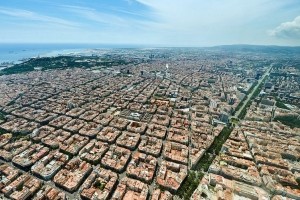
This grid pattern belongs to the Eixample area in the city of Barcelona. It’s in this district where you will find Gaudi’s Sagrada Familia.The district was built as an extension (hence the name “Eixample”) when Barcelona started to grow during the middle of the 19th century. The 7.5 square km district is characterised by long straight streets, a strict grid pattern crossed by wide avenues, and octagonal city blocks – rectangular blocks with the corners cut off, which are distinctive for Barcelona. It was designed by Spanish urban planner Ildefons Cerdà.
Incorrect
Sorry! It’s Barcelona! This grid pattern belongs to the Eixample area in the city of Barcelona. It’s in this district where you will find Gaudi’s Sagrada Familia.The district was built as an extension (hence the name “Eixample”) when Barcelona started to grow during the middle of the 19th century. The 7.5 square km district is characterised by long straight streets, a strict grid pattern crossed by wide avenues, and octagonal city blocks – rectangular blocks with the corners cut off, which are distinctive for Barcelona. It was designed by Spanish urban planner Ildefons Cerdà.
-
Question 2 of 10
2. Question
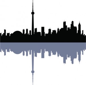
This tower is the city’s most recognisable landmark. Where on earth do you find this tower?
Correct
The CN tower, measuring at 553.33 metres high, defines Toronto’s city skyline.It was completed in 1976 and is the world’s tallest freestanding structure and world’s tallest tower at the time. It held both records for 34 years until the completion of Burj Khalifa in Dubai and Canton Tower in China both in 2010. The CN tower however, remains the tallest freestanding structure in the Western Hemisphere.
Incorrect
Sorry! It’s Toronto, Canada! The CN tower, measuring at 553.33 metres high, defines Toronto’s city skyline.It was completed in 1976 and is the world’s tallest freestanding structure and world’s tallest tower at the time. It held both records for 34 years until the completion of Burj Khalifa in Dubai and Canton Tower in China both in 2010. The CN tower however, remains the tallest freestanding structure in the Western Hemisphere.
-
Question 3 of 10
3. Question
 Correct
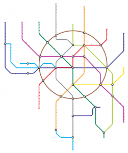
The first line of the Moscow metro was opened in 1935. It was 11 km long and had 13 stations. As of 2015, the Moscow Metro has 197 stations and its route length is 329 km. The system is mostly underground, with the world’s deepest section reaching 74 metres underground at the Park Pobedy station.
Incorrect
Sorry! It’s Moscow! The first line of the Moscow metro was opened in 1935. It was 11 km long and had 13 stations. As of 2015, the Moscow Metro has 197 stations and its route length is 329 km. The system is mostly underground, with the world’s deepest section reaching 74 metres underground at the Park Pobedy station.
-
Question 4 of 10
4. Question
 Correct
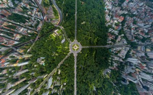
This is the Tiergarten in Berlin photographed from the sky.
Incorrect
Sorry! It’s Berlin! This is the Tiergarten in Berlin photographed from the sky.
-
Question 5 of 10
5. Question
 Correct
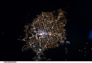
The Las Vegas Strip is said to be one of the brightest spots on earth, lit up by hotels, casinos and billboards. The pink cluster of lights in the centre of the image is the boulevard.
Incorrect
Sorry! It’s Las Vegas! The Las Vegas Strip is said to be one of the brightest spots on earth, lit up by hotels, casinos and billboards. The pink cluster of lights in the centre of the image is the boulevard.
. -
Question 6 of 10
6. Question
 Correct
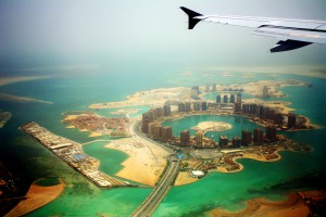
It’s Doha, did you know that more expatriates live in Doha than Qatari nationals.
Incorrect
Sorry! It’s Doha! Did you know that more expatriates live in Doha than Qatari nationals.
-
Question 7 of 10
7. Question
 Correct
The tower in the middle are the headquarters for the Bank of China. According to locals, the sharp right angles cast a negative energy. Most of the other buildings you’ll encounter in Hong Kong were designed with the feng shui philosophy in mind.
.
Incorrect
Sorry! It’s Hong Kong. The tower in the middle are the headquarters for the Bank of China. According to locals, the sharp right angles cast a negative energy. Most of the other buildings you’ll encounter in Hong Kong were designed with the feng shui philosophy in mind.
-
Question 8 of 10
8. Question
 Correct
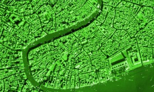
Venice is often called the “City of Water” or “The Floating City” in reference to being built across 118 small islands in the Venetian Lagoon of the Adriatic Sea. However, due to the influx of tourists and the buildings on the island, Venice is sinking at a rate of 2 mm each year.
Incorrect
Sorry! It’s Venice! Venice is often called the “City of Water” or “The Floating City” in reference to being built across 118 small islands in the Venetian Lagoon of the Adriatic Sea. However, due to the influx of tourists and the buildings on the island, Venice is sinking at a rate of 2 mm each year.
-
Question 9 of 10
9. Question
 Correct
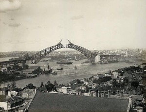
The Sydney Harbour Bridge, also affectionately known as the ‘Coathanger’, opened to the public on March 19, 1932. Today it is possible to climb the bridge to enjoy the gorgeous panoramic views of the city.
Incorrect
Sorry! It’s Sydney! The Sydney Harbour Bridge, also affectionately known as the ‘Coathanger’, opened to the public on March 19, 1932. Today it is possible to climb the bridge to enjoy the gorgeous panoramic views of the city. .
-
Question 10 of 10
10. Question
 Correct
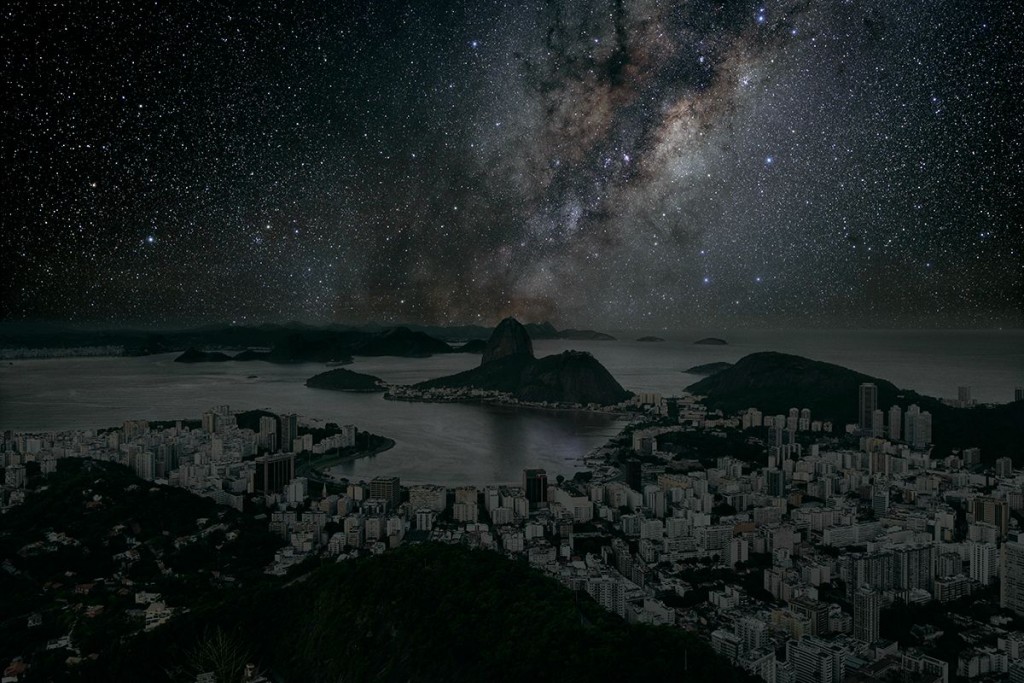
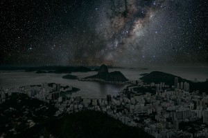
French artist Thierry Cohen depicted several cities around the world in which the skies are not polluted with light from streetlights and signs. They are lit only by a billion stars.
Incorrect
Sorry! It’s Rio de Janeiro! French artist Thierry Cohen depicted several cities around the world in which the skies are not polluted with light from streetlights and signs. They are lit only by a billion stars.


